
Fisye:Cantal-Position.png
Cantal-Position.png (200 × 214 pixels, file size: 41 KB, MIME type: image/png)
Summary
| Description |
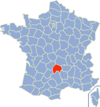
English: Map of France with highlighted department of Cantal (15).
English: Carte de localisation du département français du Cantal (15). |
||||||||||
| Date | |||||||||||
| Source | originally uploaded to the French Wikipedia. | ||||||||||
| Author | fr:Utilisateur:Rinaldum | ||||||||||
| Permission (Reusing this file) |
|

The image was created by fr:Utilisateur:Rinaldum, and :
- 19 déc 2003 à 19:20 . . Rinaldum (38242 octets) (Carte de localisation du département français 15licence GPL et GFDL)
File history
Click on a date/time to view the file as it appeared at that time.
| Kilumbu/Ngûnga | Thumbnail | Dimensions | Sadi | Comment | |
|---|---|---|---|---|---|
| bubu yayi | 02:36, 3 ngônda ya tatu 2006 | | 200 × 214 (41 KB) | Bayo | patch de la Corse |
| 20:19, 3 ngônda ya ntete 2005 |  | 200 × 214 (37 KB) | Auro~commonswiki | Map of France with highlighted #15 department. (taken from fr.wiki) {{GFDL}} |
File usage
The following page uses this file:
Global file usage
The following other wikis use this file:
- Usage on ban.wikipedia.org
- Usage on bug.wikipedia.org
- Usage on ceb.wikipedia.org
- Usage on cs.wikipedia.org
- Usage on cv.wikipedia.org
- Usage on en.wikipedia.org
- Usage on eo.wikipedia.org
- Usage on fr.wikipedia.org
- Usage on hu.wikipedia.org
- Usage on hy.wikipedia.org
- Usage on id.wikipedia.org
- Usage on ka.wikipedia.org
- Usage on kk.wikipedia.org
- Usage on ko.wikipedia.org
- Usage on la.wikipedia.org
- Usage on ms.wikipedia.org
- Usage on nds.wikipedia.org
- Usage on nn.wikipedia.org
- Usage on no.wikipedia.org
- Usage on pl.wikipedia.org
- Usage on pms.wikipedia.org
- Usage on pt.wikipedia.org
- Usage on ro.wikipedia.org
- Usage on simple.wikipedia.org
- Usage on sk.wikipedia.org
- Usage on sl.wikipedia.org
- Usage on tg.wikipedia.org
- Usage on vi.wikipedia.org
- Usage on vo.wikipedia.org
- Usage on zh-yue.wikipedia.org
- Usage on zh.wikipedia.org